Digital data courtesy Dept. Local Government and Environment |
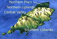
The Central Valley which separates the northern uplands from the southern uplands is thought to represent the trace of an ancient fault or earthquake zone. Glaciers and the Dhoo and Neb rivers have exploited this line of weakness to form the present valley. Major faults also run along the central spine of the Island and mark the edge of the upland areas, the most prominent of which forms the escarpment separating the uplands from the northern plain. The outline of the Isle of Man itself is influenced by large faults that lie approximately parallel to the coastline in the offshore. All of these faults are now thought to be inactive. |